")
Binevenagh (courtesy of Magilligan Gliders)
Righty Ho! Sunday’s dander this week was up a ridge on the North Coast above Magilligan. The ridge in question is Binn Fhoibhne (Foibhne’s peak – remember “bh” in irish is a “v”)

The Moon stayed up late for the Rugby Semi Finals
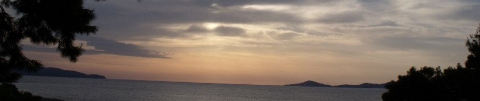
Oddly for October and even more odd given the ghastly misely pish of yesterday, today started with an azure blue sky and a slight breeze. Not summer by any stretch of the imagination but one of those rare Autumn mornings where both the sun and moon were hanging on in the blue blanket of the heavens, probably waiting to see if Australia or New Zealand made it to the Rugby world cup finals.

St.Aidan's
Andy picked me up at Chez McDonagh at 8:30 am and we arrived at the walk start point just before 9.am. We start at a place long steeped in mystery both pagan and Christian. The earliest remains of a church at St Aidan’s date back to the 13th century The Church, originally known as Tamhlacht Oirthear Arda, became known first as Teampall Chadáin or St Cadan’s Church, and this through similarity in pronunciation was altered to St Aidan’s. St Cadan was a follower of St Patrick and his grave lies under the gable of the medieval ruins. Whether St.Aidan of Lindisfarne had anything to do with this church is a moot point

St.Aidan's Well
There is a “holy” well beside the ruins which is reputed to cure any ill if the water is applied to the affected area. Excavations and local lore would indicate that this well has been in continuous spiritual use for thousands of years even as far back as the pre-christian era. Never being one to pass a chance, I had a wee drinkie and I am happy to report that I have some 10 hours later suffered no ill effects and my insides seem to be in fine fettle however it seems I am still a gobsite and these miraculous waters have perhaps not the power that has been ascribed to them. 🙁
Now the walk itself has been documented in several places however it is a shortish dander and not really long enuff for Andy and I .. so we Tweaked it a little to make it more like a proper walk and not a rather steep stroll. This is what we did….
Enter St.Aidan’s graveyard above the well and walk along the path and take the step almost directly in front of you. There is a sign that warns the steps are slippy and the paths muddy … THEY ARE NOT LYING!!. Take the steps and at the top you will find a gate, go through it and continue up the small forest path. In a couple of hundred yards you will come to a more substantive track that crosses yours. Ignore it and cross and continue in the direction of the original path. Be warned this is very slippy and muddy and claimed Andy on the way up and me on the way down. Our mucky bums stand witness to the conditions under foot. You will be climbing all the way up though the forest and in places it can be quite steep but it is generally easy going.

Coming out of the Forest
At the top of the path you will come to a sturdy style, cross it and turn left and climb a short rise and you will be greeted with your first proper sight of the cliffs. which it has to be said are very impressive and not a little daunting.
The going changes here to firm grassy meadow, but be careful there are lots of scattered granite boulders which could cause a trip to the unwary walker!

I believe this is a Welsh Cobb
There is a path of sorts which runs along the edge of the forest. Follow this keeping the forest on your left and the cliffs on your right. You will cross several walls and fences but all have either gates or styles. Please close any gates you open and keep your dogs under control if you have them with you! There are sheep, cows and horses in these fields!. Eventually you will come to a more substantial path that leads down into the forest again and the forest turns up to near the base of the cliffs.

Ulster Way Sign Post
Ignore this path and head up to the base of the cliffs and continue along the edge of the forest, through more gates and styles. Soon the forest reaches right up to the cliff edge and you should go through a gate and follow the path along for a while, still climbing until you come to a picnic table and an “Ulster way” Signpost. LIke all sign posts you should totally ignore it 🙂 if you follow it to the the right you end up on the road heading for Downhill and Castlerock. Instead take the track opposite the signpost that leads up hill. This is a forestry track and covered in loose sharp stones so go canny!. Follow the track up until it meets an intersecting track going left to right. Turn Right and continue on. After a few 100 yards the track just stops. However you should be able to make out a track leading up into the recently cleared area. It does look rather like a stream but it is actually a track.

Gortmore on the bishops road
Don’t forget to look behind you, something walkers are prone not to do, if you do you will be treated to a view over to the escarpment at Gortmore on the Bishop’s Road … and yes that is a blue sky in Norn Iron in October and yes it was quite warm!! Follow the path up until you meet the tree line. Beware!! The cliffs are about 100m to your right so keep on the path with the trees to your left!
After 1km you will come to a firebreak and the path veers to the right and takes you to within a few feet of the edge of the cliffs… it is one f**k of a long way down so keep your dogs on the lead and your wits about you. Just before you reach Binevenagh lake you will be treated to a stunning view of Donegal in the distance and Lough Foyle and Magilligan strand laid out, billiard table smooth, below you.

Binevenagh Lake
Binevenagh lake is a good place to stop and have a coffee at around 3.5 miles in and you will need it. The walk up until now has been all up hill and steep in places. There is a small damn at the end of the lake right on the path and this is a good place to stop and sit and take in the view. Although the walk has been lovely up to now the best is yet to come!.

Glider
Once rested and coffeed keep on the path and leave the lake behind you, If you are lucky you may see gliders skim the ridge top only feet above your head.
If you are REALLY lucky you will see nature’s gliders, falcons, buzzards and even an eagle. No such luck for us today but we did have 3 man made gliders for company.

The Narrow Path
Follow the path down and soon you will come to a VERY VERY Steep bit that runs down the steep ground at the end of cliffs. Around half way down turn right and follow one of the sheep paths along the cliffs between cathedral high buttresses and in and out of depressions, ridges and hummocks. This is truly stunning and well worth the effort of getting around. There are some pretty sheer slopes, but they are grassy and the risk of injury is slight,

Cliffs
Mind you, be careful of the boulders that are scattered everywhere having fallen from the cliffs above which are … well … pretty awesome.
Follow the cliffs around until you find a bright blue pipe running along the ground. Follow this pipe down and you will end up back in the meadow at the top of the forest. Turn left and you will find the style and then it is just a case of following the path back to the car park at St.Aidan’s.
This walk is not the longest at 7 Miles, not the highest at 380m, but pick your day, wear clothes you don’t mind getting muddy, take a stout stick and a friend and you will not be disappointed. This is a 10/10 walk!
PS Here is a link to the FB gallery of all the pictures I took
 Steve's Email
 Steve's Twitter
 Comment RSS